
Cascadia Marine Trail Trip Suggestions
"Short & Sweet" Overnights - Under 10 nm roundtrip
Hop on Over to Hope Island
Escape to Blake Island
Paddle to Saddlebag
Hop on Over to Hope Island
 Distance: 3.5 nm round trip
Launch/Landing: Arcadia Point Public Boat Ramp
Directions: From Olympia, N on US 101 for 15 miles; E on Lynch Rd. 9.5 mi; ramp at end of road
Charts: NOAA chart 18445, SeaTrails chart WA 205
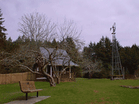
Description: Hope Island State Park is home to meadows, orchards, hiking trails and the remnants of a historic homestead. At lower tides, you can hike the approximate 2 miles around the island on the beach. The Cascadia Marine Trail Site is located on the southwestern shore of Hope Island, with additional campsites available to the east. Above the Cascadia Marine Trail site, you will find an apple orchard, caretaker’s cabin, hiking trailheads, and vault toilet.
Special Considerations: Water is not available on the island and fires are prohibited. Camping fees are $12 per night, for up to six people. Pets are not allowed on the island.Escape to Blake Island
 Distance: 3.2 nm round trip
Launch/Landing: Manchester Boat Launch
Directions: From Port Orchard, SR 160; W to Colchester Ave 1.75 mi; R on E. Main St. Overnight parking on the street only.
Charts: NOAA chart 18449, SeaTrails chart WA 203 & WA 202
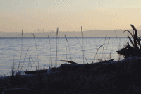
Description: Blake Island State Park is a surprising refuge amid the urban bustle of Mid Puget Sound. The Cascadia Marine Trail on the Island’s northwestern point has a sweeping view of the Seattle skyline. Upon landing, be sure to use designated trails and stay off the grass – Blake Island is the site of on-going dune grass restoration. Enjoy a 3.4 nm circumnavigation of Blake or stretch your legs on the many hiking trails. Hike 1.25 miles east to Tillicum Village and enjoy a salmon dinner and traditional Northwest Coast tribal dances.
Special Considerations: Water is available during summer months at campsites to the southwest of the Cascadia Marine Trail Site. Bring your own firewood and use fire rings for campfires, driftwood collection prohibited. Camping fees are $12 per night, for up to six people.
Paddle to Saddlebag
 Distance: 6.6 nm
Launch/Landing: Cap Sante Boat Haven
Directions: From 1-5, take SR20 to Anacortes; N on Commercial Ave; E on 11th to marina.
Charts: NOAA chart 18427, SeaTrails Chart WA 001
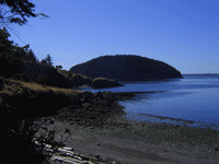
Description: Saddlebag Island State Park is made up of a pair of wooded headlands connected by a low pass, hence the name. The Cascadia Marine Trail site is on the southern shore of the low pass (three additional campsites may be found on the northern shore). The island is adjacent to the Padilla Bay National Estuarine Research Reserve, a fertile estuary at the delta of the Skagit River. Padilla Bay contains nearly 8,000 acres of eelgrass, used as a nursery for crab, salmon, herring, and perch. Nearby Dot Island is a wildlife refuge, please stay 200 yards offshore.
Special Considerations: When crossing Guemes Channel, watch for heavy boat traffic and strong currents and tankers entering Fidalgo Bay. Water is not available on Saddlebag. Fires are permitted in established fire rings, please bring your own wood and check for burn bans. Camping fees are $12 per night, for up to six people.